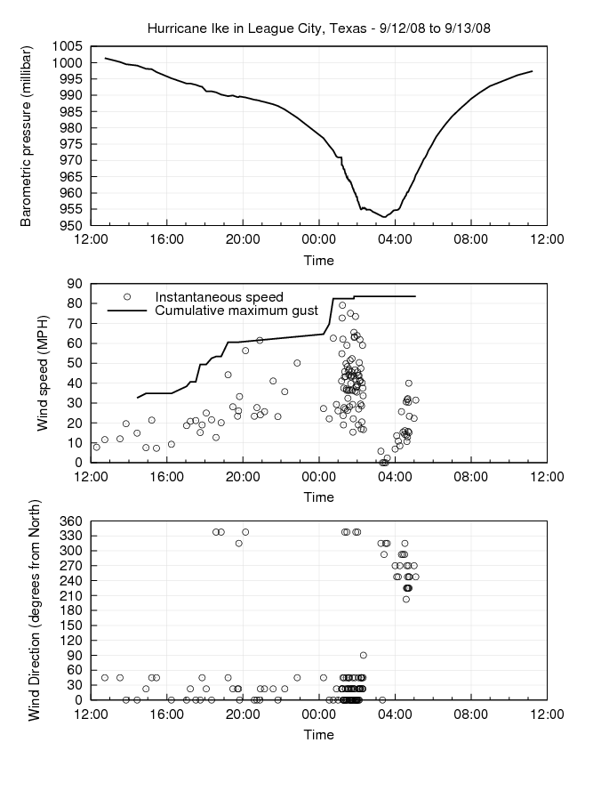
Hurricane Ike hit the Texas coast on the night of 9/12-9/13/2008. The eye passed over League City, Texas where a weather instrument had been set up at a friend's house. Unfortunately the instrument had failed a few months before but as the storm approached we were able to get it running again to some extent. The automatic data recording ability still didn't work so barometric pressure, wind speed and wind direction were recorded manually at somewhat random intervals.
The three graphs below show the barometric pressure, wind speed and wind direction as the storm passed over League City. Passage of the eye is obvious between about 2:00 and 4:00 AM. The wind was very unsteady throughout the storm. Since readings were only taken at random times never less than 1 minute apart the instantaneous wind speed is highly variable. The instrument also records the maximum gust seen since the last reset which is shown by the line labelled "Cumulative maximum gust". The maximum gust seen during the first half of the storm was 83.6 MPH. Readings from 3:20 to 3:30 AM, during passage of the eye, showed the wind speed had dropped to zero.
The anemometer did not keep working throughout the full length of the storm. As the eyewall was passing over the first time and the winds were dying down contact was lost with it for about 30 minutes. It resumed sending data for about 20 minutes during the middle of the eye before going offline for another 20 minutes. It finally died for good at 5:05 AM as winds were building in the eyewall once again.
| Return to Home Page | Last updated: November 12, 2008 |